KayakIng Day 3, October 31, 2018
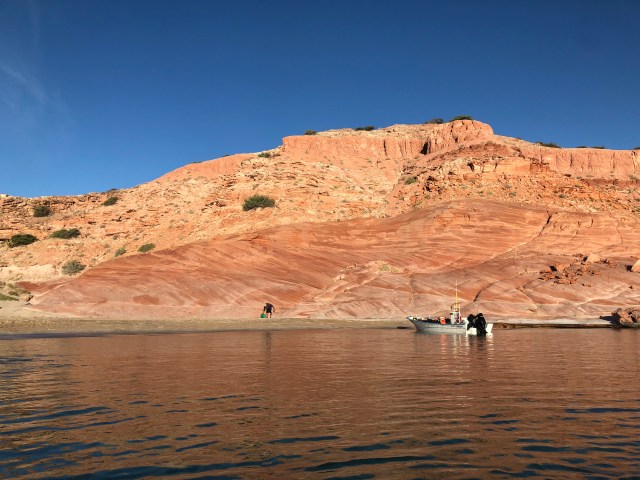
As we cast off from the beach the next morning, I turned to look back at our campsite. In the bright morning sun, the variegated rock strata surrounding us stood out vividly. I had not scrambled up the adjacent slope the night before to see what was there, but the lower layer was clearly some type of sandstone.
While researching background material for this post, I stumbled upon a relevant scientific paper with the tantalizing title: Structural Analysis, Stratigraphy, and Geochronology of the San Jośe Island Accommodation Zone, Baja California Sur, Mexico. It’s a 284-page master’s thesis written in 2005 by William Drake, a student at Northern Arizona University, and it answered many of my questions about the terrain along the route we were paddling.
What is now the Baja California Peninsula was originally the western edge of North America where that continental plate came into contact with the Pacific basin plates. Around 29 million years ago, the Pacific plates began to push into and slide (or subduct) under the North American plate, lifting and fracturing the surface and thereby forming mountain chains and volcanos all along the Pacific coast of North America.
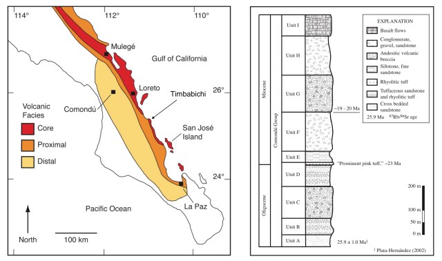
Along the westernmost edge of what is now Mexico, that volcanic mountain chain was called the Comondú arc. The ash and lava spewed into the world by the volcanos of the Comondú arc built up over the millenia, layer upon layer, forming alternating strata of sandstone and volcanic tuff – ash and other volcanic detritus cemented together by heat – all of which overlaid the base granite. West of the ridgeline, layers of limerock had also formed from maritime sediments. Plate subduction and volcanic activity along the Comondú arc began to wane about 12 million years ago and today’s remnants are shown in the map below, left.
The oldest rocks created in the region by this process are located near the village of Timbabichi, approximately where we had just camped. Drake’s thesis includes a columnar section of the rock here (below, right) describing and dating the various layers visible today and shown in the photo at the top of this post. It appears that each layer can be identified with a particular period of volcanic activity (for example, the “prominent pink tuff” was deposited by volcanic eruptions around 23 million years ago), with the final deposit being basaltic lava near the end of the Miocene Age about 6 million years ago.
Between 6 and 8 million years ago, the Pacific plate stopped its head-on collision with the North American plate and instead began to slide left, that is, north. Thus began what scientists call an “oblique-divergent rift” or “strike-slip fault.” As the Pacific plate has continued to slide north along the North American plate, it has torn loose and claimed as its own a strip of the North American plate – the Baja California Peninsula:
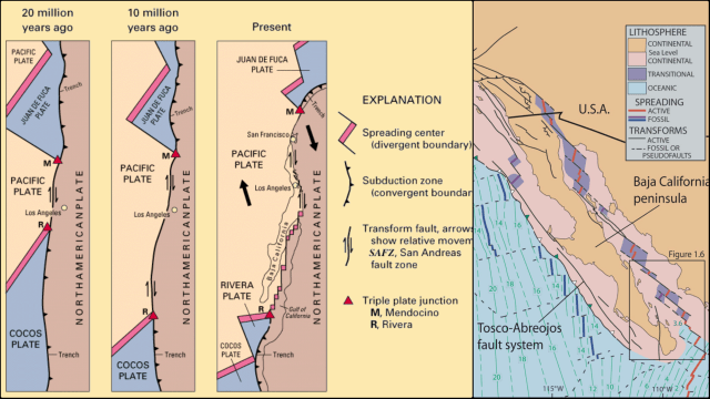
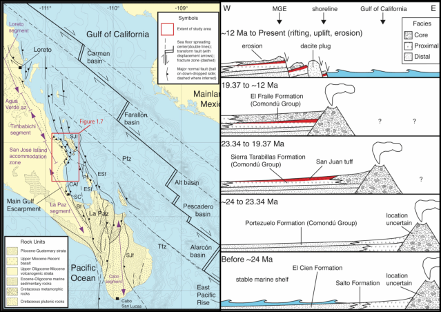
This separation of the peninsula from the mainland also created the Gulf of California as the earth’s crust between the peninsula and the Mexican mainland has stretched and thinned, spreading the seafloor. And as the peninsula has continued to move westward, the southernmost volcanos have become dormant and extinct and the eastern shore of the peninsula has collapsed and fallen into the Gulf (below, right).
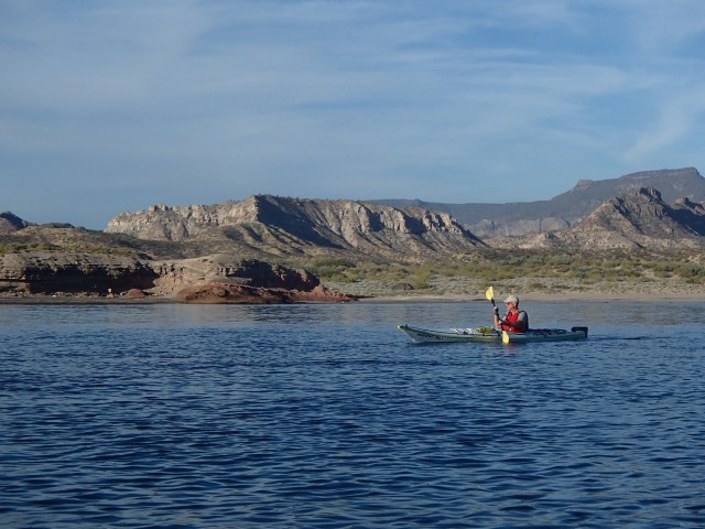
But, enough about rocks. It was a magnificent morning as I followed Dale out toward open water…

… and our short 3 mile paddle to Ensenada Timbabichi, the cove and beach just north of the small village of Timbabichi.
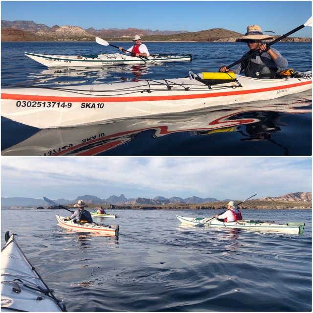
Here’s one of the few photos I have of myself, taken by Lino as he idled nearby.
We were on the beach at Ensenada Timbabichi before 10:00. We went for a swim, set up camp and had a sashimi lunch, the sea bass Lino had caught the previous day,…

… then lounged around in the shade for a while, reading and napping…

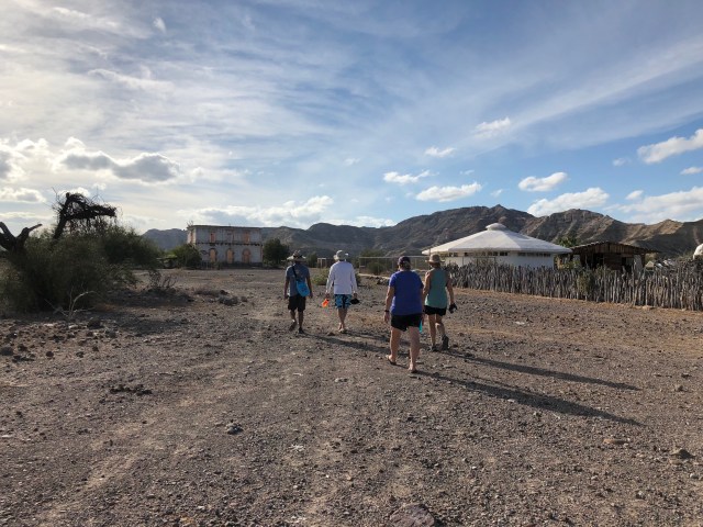
before making the 3/4 mile trek with Mario down the beach to the village of Timbabichi to see the old manor house that Mario said had been here since before the Mexican Civil War (1910-1920).
On the walk in, we passed the new schoolhouse, a prototype geodesic building that the Mexican government plans to use for rural schools throughout the country (the old school it replaced is to the far right):
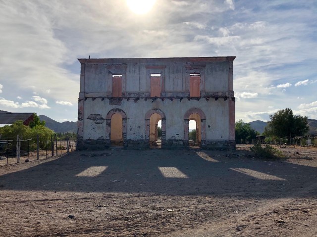
As I have since learned, the old manor house was, indeed, built before the Mexican Civil War, probably in 1907. According to the “official family history,” as recounted by a prior traveler:
The community’s founders were a Señor Donaciano de la Toba, his wife Germana Mesa, and the first of their daughters, who were then three and seven years old. The family took possession of the area in 1901. In the first years, the family likely engaged in subsistence fishing, ranching and gardening to get by. But the principle reason that brought the family to such a lonely outpost on the peninsula was pearling, which was still the main economic activity of the southern peninsula.
The family’s fortunes changed dramatically in 1906 when don Donaciano found a four-carat green pearl in the nearby Estero del Cochi. In April of that year he traveled to La Paz on a passing Spanish ship and sold the pearl for 40,000 pesos, which was a considerable sum of money in those days. With some of the profit he bought a boat from which to work the pearl beds off Timbabichi.
Lightning struck twice in Timbabichi that year, for a month later don Donaciano found an even larger pearl, this one reportedly weighed five carats and sold for 50,000 pesos in La Paz. With these profits, don Donaciano bought building materials and contracted brick layers in La Paz to go out to his property and build the hacienda that we see today. It would be the last of the spectacular pearl finds for don Donaciano. The rest of his pearling days produced only small samples that didn’t matter enough to mention in the family lore.
If you’ve read John Steinbeck’s, The Pearl (1947), this story may sound vaguely familiar. Kino, the protagonist in that tale, also found a pearl he believed to be worth 50,000 pesos, but the local pearl merchants in La Paz tried to cheat him with collusive offers of only 1,000 pesos, setting off a tragic chain of events.
Steinbeck cruised this coast for 6 weeks in 1940 collecting marine specimens. He chronicled the voyage in The Log From the Sea of Cortez (1940) and I suspect he heard the tale of don Donaciano – possibly from the don, himself – perhaps his inspiration for The Pearl, published seven years later. If so, this would have been Kino’s dream house:
With the decline of pearl fishing in the Gulf of California (Sea of Cortez), don Donaciano’s hacienda took on the role of regional trade center, a location visited by coastal steamers where local ranchers could do business with the larger world. A warehouse was built and the family turned to cattle raising on a large scale. To keep the house cool, a kitchen was constructed in an adjacent building, which now serves as a residence for one of the few families that still live here. More recently, a large cistern was constructed, although it is no longer in use.
The 10 to 20 families that comprise the settlement of Timbabichi supposedly all descend from the original Spanish Toba settlers by blood or marriage, although over the years many have moved away. It seems that family feuds are at least partially to blame for the demise of the hacienda and the community, as I found several news reports (in Spanish) of disputes alleging that some family members had forged documents and fraudulently attempted sell the property, while others had sought to dissociate from the Municipality of Loreto in order to develop the property without oversight against the will of the majority of the residents.
At any rate, no one has made any attempt to maintain the manor house for years, as it gradually succumbs to the elements and descends into ruin.

At one time a dirt airstrip had been cleared and sportsmen flew in private planes to Timbabichi on fishing excursions, but no more. Sometime after 1995, a rough dirt road was built to the community and several of the residents do own cars, but we saw only one during our visit.
The Mexican website that reports on the small villages of rural Mexico, PueblosAmerica, reports that: there are currently 66 residents in the Timbabichi community; most of the houses have electricity, supplied by solar panels provided by the government; and, water is piped in from a well in an arroyo a mile away and then distributed to the houses through pipes leading from the defunct cistern – but fewer than 2/3 of the houses have indoor bathrooms. There is no internet nor landline nor cellular telephone service, but 20% of the people own mobile phones, presumably for when they go into the city. There are no refrigerators or washing machines in the village, but nearly half the houses have satellite TV – you’ve got to have priorities, right?
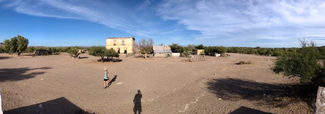
I climbed up on the old cistern to take a panoramic photo. I didn’t count more than a handful of dwellings, so I suppose the other houses in the community are simply out-of-sight, but nearby. At any rate, there are enough people still living here to justify having a one-room schoolhouse.
On our walk back to camp, the discussion turned to the controversy then being widely promoted in the commercial U.S. media about “undocumented” migrants illegally crossing the border from Mexico and the caravan of Central Americans making their way north through Mexico to the U.S. border.
Mario surprised me by commenting, “I don’t mean to offend, but I don’t understand why anybody would want to move to the USA?” In light of what we had just seen of the conditions in Timbabichi, I was dumbfounded, feeling that Mario’s remark exhibited a lack of empathy. After all, he had been raised in an upper-middle income family in urban Mexico City (his father was a lawyer) and he was well-educated (Master’s degree in Environmental Tourism, if I recall), so the opportunities available to him differ greatly from those available to the refugees of El Salvador or Honduras or, for that matter, rural Mexico.
But the more I thought about what Mario had said, the more I came to realize that his comment had not come from a perspective of privilege. To him and to many in the broader world, America may not be that “beacon of hope” or “shining city upon a hill” that we Americans believe it to be. People of all stripes have a love for life exactly as, where and how they live it – maybe because their situation in life offers equivalent opportunity, as it does for Mario, or maybe because, as it is for Lino and the residents of Timbabichi, they strive for something other than tangible wealth or independence, something like family or community or just a having a sense of place and purpose in the world.

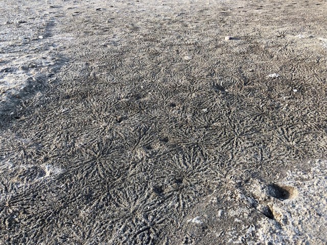
As we neared the beach, we came upon an area covered with the most interesting patterns in the sand. We ultimately decided these were crab holes, the tracks made by their occupants.
Back at camp, Lino prepared beef tacos. As night fell, Mario lit a campfire and then produced a blacklight and a surprise: Mario, Scott and I would go searching among the Cardón (Elephant Cactus, Pachycereus pringlei) for scorpions which light up under the glare of a blacklight. Unfortunately, that combination does not photograph well.

Great post 🙂
LikeLike
Pingback: Jurassic National Park | The Road Less Traveled
Have been many times in timbabiche. Walk from Aqua Verde every year
LikeLike
Walk there every year from Aqua Verde. Love vet it there.
LikeLike
Great write up! I love the paragraph about not understanding why migrants would want to come to the USA. Family and purpose in life so much more important than wealth but too many gringos don’t get it.
LikeLike