We returned “home” last night, Saturday, from a whirlwind tour of Jutland, logging 633 miles in 3 days.
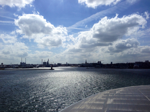
Our trip started Thursday afternoon with a short ferry ride from Hundested to Rørvig, followed by a high-speed ferry to Århus on the Jutland peninsula. About 1/3 of our first day of travel was by ferryboat. Here’s the view of Århus from the ferry.
Jutland looks a lot like the lower peninsula of Michigan: it has the same general glove-like shape; and, it, too, is low, rolling farmland.
The upper two-thirds of the Jutland peninsula is part of Denmark (the Danes call it “Jylland”); a little less than half of the population of Denmark lives there.
The southern one-third of the peninsula is part of Germany (“Jütland” in German), comprising the German state of Schleswig-Holstein. The cities of Hamburg, Lübeck and Travemünde are all in Schleswig-Holstein. We visited these cities two years ago from Amsterdam where we had another home exchange. I lived in Travemünde for 6 weeks in the Summer of 1980, the year I crossed the Atlantic with my friend and college roommate, David Stehlin, on the M/V Knista, a 160-foot long german-built canal boat that the Stehlins were putting into service as a freight boat in the Bahamas.
The border between Jylland and Jütland is near the Danewirk, a defensive earthwork built across the peninsula at the shortest distance between the North Sea and the Baltic by the Vikings to protect against invasion from the South by the Franks.
From Århus, we drove to the far northern tip of Denmark to the town of Skagen (pronounced “Skane”), where we spent Thursday night.
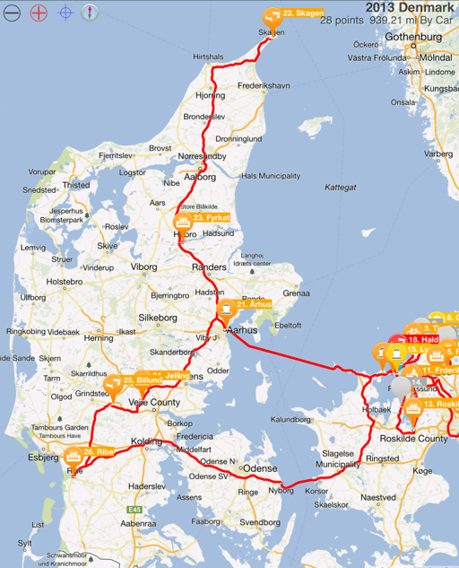
After spending Friday morning in Skagen and walking out to the point at Grenen, we drove south to the Viking ring-fortress at Hobro, continued south to Jelling, the burial site of Gorm, the Viking, then spent Friday night at Billund which, we discovered, is the home of Legoland.
On Saturday, we drove to Ribe and spent the morning walking around this well preserved medieval town, then spent an hour or two at Ribe’s Viking museum before heading back to Hundested.
Our timing was good: we left in rain and returned in rain, but had mostly sunny days the entire time we were sightseeing.
Leaving Jutland, we drove across the island of Funen, then crossed the Great Belt Bridge over the Storebælt Strait to Zeeland. The bridge is relatively new, opened in 1998, and consists of a girder bridge (the West Bridge) and a suspension bridge (the East Bridge); train tracks parallel the West Bridge on a bridge of their own, then dive below the strait into a train-carrying tunnel parallel to the East Bridge.
The East Bridge, at just over one mile long, is the third longest main span of any suspension bridge in the world (it’s the longest span in the world outside of Asia). To me, it also seemed like it must be the highest suspension bridge in the world – the clearance below the bridge is an amazing 213 feet! I suppose it has to be that high because the eastern part of the Storebælt Strait, underneath the suspension bridge – though surrounded on all sides by Denmark – is now an international waterway and shipping lane. Huge freighters, cruise ships, tankers and container ships pass through the straits, without need to pay toll or duty.

As you can see, it was raining and there was a terrific crosswind as we passed over the bridge.
Unlike the international shipping below us, we had to pay a toll to cross the bridge: 235 Kr., approximately $42.00. But it was definitely worth it – not only for the time it saved us over returning by ferry, but also, just for the experience of it.
