Only three settlements of the Southeast Alaska Panhandle are reachable by road and we have visited them all: Hyder, Skagway, and now Haines, although we didn’t get to Haines via its highway connection, the Haines Highway, which runs north through British Columbia and the Yukon to Haines Junction. We will be leaving by that route, though, a week from now.
The borough of Haines, population 2,459 in 2017, sits on the Deshu Isthmus that connects mainland Alaska on its the north with the Chilkoot Peninsula on its south. For many years, there had been a settlement here of the Tlingit Nation’s Chilkat clan. They used the isthmus as a portage between the bodies of water on either side of the peninsula, the Chilkat and Chilkoot Inlets.
A trading post was established here in 1878, followed in 1881 by a Presbyterian mission. These American pioneers named their settlement Haines after Francina Haines, chairwoman of the Presbyterian Board of Home Missions, although she never visited the place. In 1904, a U.S. Army base, Fort William H. Seward, was established here on land donated by the mission. It was the only Army post in Alaska during the time between the great wars, deactivated and closed in 1946 and sold to private investors. Today, the officers’ quarters at Fort Seward overlooking Chilkoot Inlet are a mixture of B&Bs, private residences and businesses.

The Chilkoot Peninsula on which Haines is located divides the northern end of the Lynn Canal into the Chilkat Inlet to the west and the Chilkoot Inlet to the east. Near Haines, the Chilkoot Inlet splits again into the Lutak Inlet on the west and the Taiya Inlet on the east; Skagway sits at the northern terminus of the Taiya Inlet.
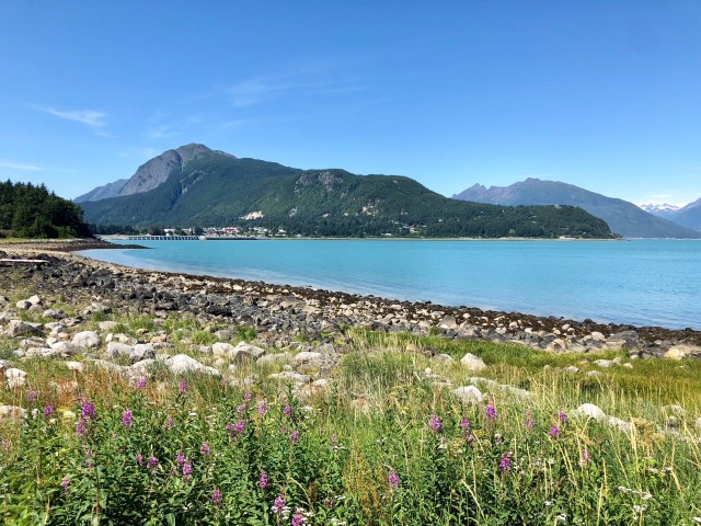
North of Haines is Mt. Ripinski (elevation 3,375′) and to the south is Mt. Riley (elevation 1,608′). Here’s a photo of Haines from the Chilkoot Inlet side, just south of Fort Seward, with Mt. Ripinski in the background:
We checked into the Haines Hitch-Up RV Park for a week, a meticulous little roadside campground, although we will not personally be there for the entire time because we’re taking a side trip to Glacier Bay N.P. for a couple days.
On our first full day in Haines we went on a kayaking excursion in Chilkoot Lake. To get there, we were bussed north to the end of Lutak Inlet and the mouth of the Chilkoot River where we stopped to take in the view before proceeding to the lake:
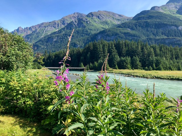
One of our guides explained that the plant in the foreground, above, is Fireweed, used by the locals as a seasonal marker. The blooms, climbing the flower stalk, mark the approach of winter and when they reach the top, summer is over.
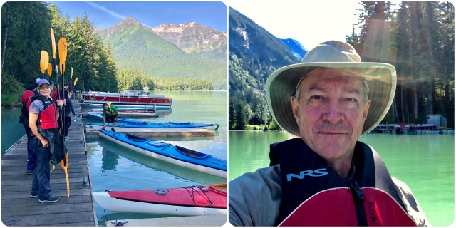
Arriving at Chilkoot Lake, we found our boats already in the water. After a short safety lesson, we climbed into our double kayak and began paddling our way clockwise around the lake.
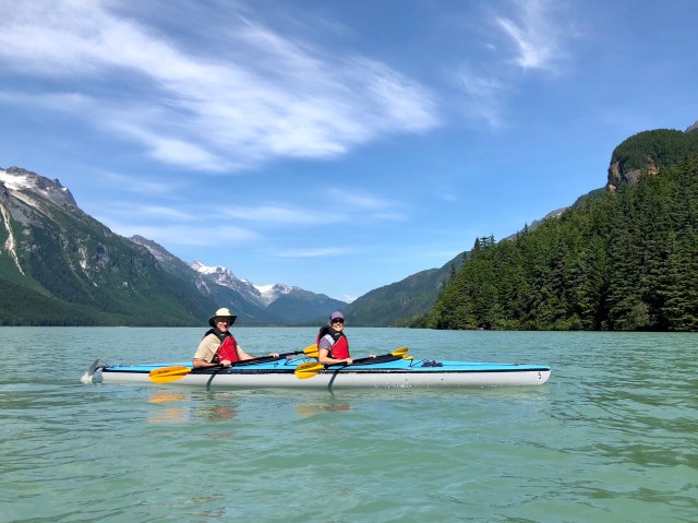
The Chilkoot River flows south from a glacier of the same name in British Columbia, filling Chilkoot Lake with icy meltwater. We were told that below the upper foot-deep thermocline the water is a chilly 40° F.
After our paddle, we drove back to Haines, following the Chilkoot River to where it flows into the Lutak Inlet. That’s Cow Parsnip in the foreground (white flowers); it’s edible and supposedly tastes like celery.

In the afternoon we drove south around the peninsula. Below is a view of Chilkat Inlet on the west side with the Chilkat Range in the background. On the other side of this mountain range is Glacier Bay N.P. The tide was out when we arrived and people had hiked down to and across the tidal flats. When we drove by again the next day, this entire area was underwater.
Further down Chilkat Inlet we stopped to take a photo of a local marina. What a tidal range, around 15 feet!

Around to the east side of the peninsula we came upon aptly-named Mud Bay. Those are the Coast Range mountains on the mainland in the background.

The next morning we walked from the campground to the weekly farmer’s market, held at the nearby Southeast Alaska Fairgrounds. Just inside is “Dalton City,” a movie set that was used to film White Fang, starring Ethan Hawke, in 1991, a Disney flick based on the Jack London novel of the same name. The set was donated to the Haines community which was responsible for moving it from the filming location a few miles away. We wandered the market to get a flavor of the local populace, but couldn’t buy anything since I had forgotten to bring cash on the walk.

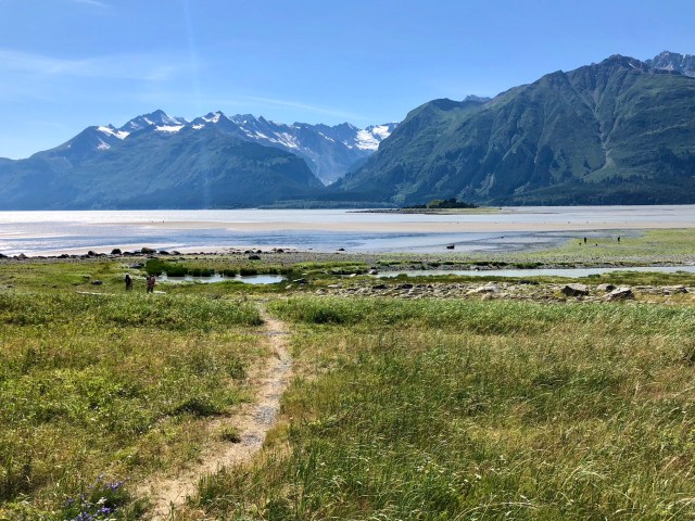
After lunch, we drove back south to the Mt. Riley trailhead for a hike to the summit. The first 1/2 mile of the hike is flat, passing frequently through boggy areas over boardwalks, but the trail soon heads uphill.

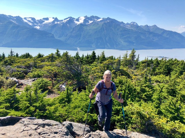
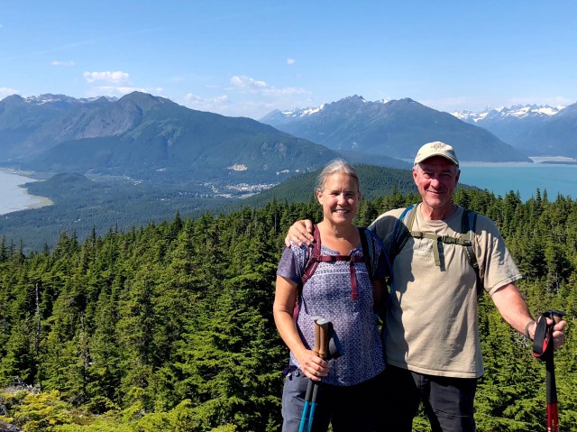
From the trailhead down on the road, about 150′ above adjacent Chilkat Inlet, it’s a 2.8 mile hike to the summit with a 1,465 foot elevation gain. Here’s Dale reaching the summit with the Chilkat Range in the background.
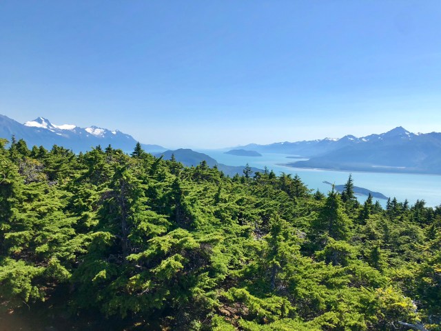
We were told that there are only two types of conifers in this part of Alaska: Sitka Spruce and Western Hemlock. They have a similar appearance, but their needles have a different texture. Here’s a view looking south from the summit over those trees and down the Lynn Canal.
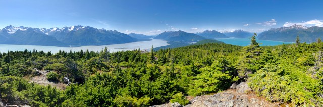
Looking north from the summit we could see how the Chilkoot Peninsula splits the Lynn Canal into the Chilkat (left) and Chilkoot (right) Inlets. Notice the difference in the water color. The Chilkat is glacial meltwater, filled with silt, giving it a cloudy appearance. The Chilkoot is saltwater at this point, being further downstream from its glacial source, so it’s blue and clearer.
There was a young woman from Fairbanks at the summit when we arrived. She had hiked up in plastic slippers and said she had driven 13 hours from Fairbanks to visit Haines because Alaskans think it’s the prettiest part of the state. We chatted for a while and she offered to take our photograph, “just $50,” she joked. That’s Haines in the background, surrounded on all sides by water and snow-capped mountains.
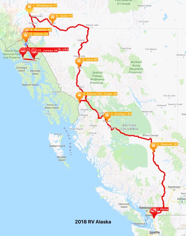
Here’s a map of our travels so far, including our upcoming flight to Gustavus and Glacier Bay via Juneau.
I have to agree with the woman from Fairbanks. Haines is heavenly, my favorite stop on our trip so far.

Pingback: Parks Highways | The Road Less Traveled