The largest non-polar icefield in the world is divided between the USA and Canada and carved up into four national parks: Glacier Bay NP and Wrangell-St.Elias NP in the USA; and, Tatshenshini-Alsek NP (British Columbia) and Kluane NP (Yukon) in Canada. Combined, as formed by nature, these four parks are considered to be an outstanding wilderness of global significance, designated a UNESCO World Heritage Site in 1980.
Canada’s Kluane National Park and Reserve sits at the heart of it all with Mt. Logan, Canada’s highest peak, in that park’s southwest corner. Mt. Logan (elev. 19,551 feet) is also the second tallest mountain in all of North America after Mt. McKinley in Alaska (n/k/a Denali, elev. 20,308 feet).
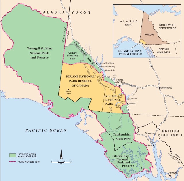
As I mentioned in my last post, we drove the eastern boundary of one of these parks, Tatsheneshini-Alsek NP, on our way to Kluane Lake and we previously visited, boated and kayaked in another, Glacier Bay NP in Southeast Alaska. Ahead of us in a few days is a visit to Wrangell-St.Elias NP. So, before another week passes, we will have circumnavigated this entire World Heritage Site.
But now, let’s get back to Kluane. The Kluane Range forms the northeastern edge of Kluane NP and is ringed by the Alaska Highway. Yesterday, we drove past Kathleen and Dezadeash Lakes on the Alcan on our way north to our campsite on Kluane Lake, the largest lake in the Yukon. We have now returned to Kathleen in order to hike the King’s Throne Trail. That high rock bowl in the photo, below, is our destination, the remnants of a hanging glacier, long since melted.

The Kluane Range lies in the rain shadow of the St. Elias Mountains to their southwest and as a result, the eastern slope is generally very dry.

In the valley, however, there is still enough moisture and soil for a montane forest of white spruce, trembling aspen and balsam poplar to thrive, although over time the spruce will come to dominate, as is beginning to happen now.

The trail heading up to the seat of the King’s Throne traverses back and forth through a former icefield which having melted has fractured and eroded the sedimentary rock above, causing it to spill down the mountainside in a wash of scree.

We had to pay close attention to our footing on this loose rock, sand and gravel, so we stopped periodically on our way up in order to take in the view of Kathleen Lake below. I learned after the hike that Kathleen Lake is home to a landlocked sockeye salmon called Kokanee, stranded here when the nearby Lowell Glacier caused an ice dam in the 1700s that blocked the Alsek River and flooded the area all the way to Haines Junction. The ice dam broke in 1850, draining the area, but leaving several lakes, including Kathleen with her stranded salmon.

Of the 15 trails described in the 2014 version of the map of Kluane National Park published by Parks Canada, the country’s park service, only two are described as “difficult:” King’s Throne; and, Cottonwood Loop, a 4-6 day, 53-mile backpacking trail. All the others are called “easy” or “moderate.”
Here’s why King’s Throne is called “difficult:”
What you need to know: The steep scree and rock slopes encountered on this trail and route can be unstable and can present some difficult hiking. Weather is another factor to consider on this route. Strong wind gusts can be a hazard on the exposed ridges. Also watch for clouds, which can descend rapidly and make finding the trail or route difficult. Sturdy footwear is recommended for the trail and route. Also, the rocks will be slippery on rainy, wet days, so use caution. Bear sightings are common in the area. Review bear safety information in the You Are In Bear Country brochure. All bear sightings should be reported to the staff at the Kluane National Park and Reserve Visitor Centre in Haines Junction.
Um, yeah. Wish I would have read that BEFORE we started the hike.

We hiked upward through the skree until the trail became so difficult that we stopped to reconsider whether or not to continue. As we rested, a German girl came slipping and sliding down the trail from above. When questioned, she said this sketchy condition of the trail continued all the way to the top.
I should probably note that in addition to the trail becoming very loose and unstable, the wind had picked up to about 20 mph, the switchbacks had begun to disappear as the trail headed ever upwards, approaching a nearly 60° grade. Considering that a slip and a fall would be disastrous since we were above the tree line and, therefore, without anything to grab onto to stop a slide all the way down the mountain, we decided to turn back.
At least we didn’t have to contend with clouds or bears. Still, we made it nearly all the way to the top, a 1,300-foot ascent.

Approaching the valley floor, we came upon the “Queen’s Throne,” a perfect setting for a photograph.

On our drive back north, we stopped just before the Slims River crossing to examine the site of the next day’s hike, the Sheep Creek Trail which climbs up from the river in the center of the photo, below, then up and around Wallace Mountain, the mountain on the right, for a distance of 3 miles and an elevation gain of about 1,500 feet. Rated a “moderate” hike by Parks Canada, it looked like an enjoyable trek. We returned to the campground for the night.

The following day we began our hike on an old mining road at the base of Wallace Mountain as we scanned the uphill terrain for Dall Sheep, known to inhabit the area.

We didn’t see any sheep, but we did see a couple Arctic Ground Squirrels:

The old mining road continued a fair distance up the mountainside, making for a hot and dusty trek at the lower elevations. Gold was discovered here in 1903, but not much was found and the claims were soon abandoned.

As the trail curved around Wallace Mountain, I stopped to take this photo looking back south across the Slims River,…

… then I turned slightly to the southwest to take this one, looking upstream toward the river’s source, the Kaskawulsh glacier

The trail left the mining road and we started a long and steady ascent.

For awhile we hiked through white spruce. Dale noticed that many of these trees host the parasitic Witche’s Broom fungus, the orange mass you see in the tree farthest to the right:

This entire area is a Gizzly Bear Protection Area and somewhere between 200 and 300 Grizzlies are believed to live in this part of Kluane NP, so we carried bear spray and air horns for protection and I was constantly on alert for evidence of the critters, such as fresh tracks or scat. We didn’t see either of those, but we did come upon an area that had been very recently dug up, possibly a bear pursuing one of those ground squirrels, as well as several trees that had their bark clawed down, like this one (Grizzlies do this to mark their turf):

We kept up a steady pace, keeping a watchful eye for both bear and sheep.

At another barkless spruce, this one not evidencing claw marks, we discovered this woodpecker’s nest:

Arriving at the end of the trail, we sat and had lunch. From here we could just make out the Kaskawulsh glacier high up on the mountain to the right. An interesting thing about this glacier – its meltwater drains in two directions: to the north, creating the Slims River, into Kluane Lake and ultimately into the Yukon River, then west to the Bering Sea; but, also, to the east and south into Kathleen Lake, then southwest into the Alsek River and ultimately to the Gulf of Alaska.

We enjoyed our time in Kluane National Park. Perhaps we’ll be back some day without the RV. Whitehorse is just 100 miles to the east with a direct flight from Vancouver (as well as direct flights from Frankfurt, Germany, and Zurich, Switzerland, explaining the number of Germans and Swiss in our campground and on the trails).
