After Zion, we spent several days in Escalante, Utah, exploring the Grand Staircase-Escalante National Monument. The Monument was established by President Bill Clinton in 1996 pursuant to the Antiquities Act of 1906, by which Congress granted the president the power,
in his discretion, to declare by public proclamation historic landmarks, historic and prehistoric structures, and other objects of historic or scientific interest that are situated upon the lands owned or controlled by the Government of the United States to be national monuments, and may reserve as a part thereof parcels of land, the limits of which in all cases shall be confined to the smallest area compatible with proper care and management of the objects to be protected;… 16 USC 431-433, §2 (emphasis added).
The effect of Pres. Clinton’s proclamation was to further preserve 1.7 million acres of federal property in southern Utah by preventing it (and the oil and minerals under it) from being leased or sold into private hands.
Here’s how Pres. Clinton described the significance of the region in the first paragraph of his proclamation:
The Grand Staircase-Escalante National Monument’s vast and austere landscape embraces a spectacular array of scientific and historic resources. This high, rugged, and remote region, where bold plateaus and multi-hued cliffs run for distances that defy human perspective, was the last place in the continental United States to be mapped. Even today, this unspoiled natural area remains a frontier, a quality that greatly enhances the monument’s value for scientific study. The monument has a long and dignified human history: it is a place where one can see how nature shapes human endeavors in the American West, where distance and aridity have been pitted against our dreams and courage. The monument presents exemplary opportunities for geologists, paleontologists, archeologists, historians, and biologists. (emphasis added)
Having spent time in the Monument, I can confirm that President Clinton’s description is accurate, especially that last sentence which I have italicized.
The town of Escalante (where we are staying) was first settled around 1875. In 1879, a group of Mormons arrived in the area on their way further south with the intent to establish their own settlement and mission at what is today Bluff, Utah, 200 miles distant. They established a wagon road that ran in a southeasterly direction from Escalante to a bluff overlooking the Colorado River where they widened a hole in the rock in order to continue down to the river and beyond. The trail became known as the Hole-in-the-Rock Road, listed on the National Register of Historic Places in 1980.
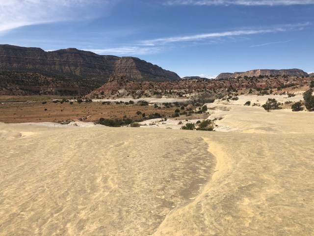
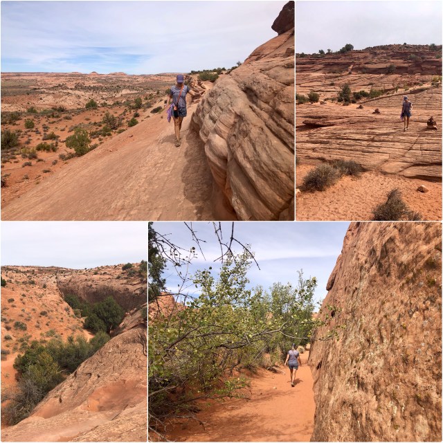
We drove south on Hole-in-the-Rock Road, which today is a washboarded and dusty dirt road. Our first stop was the Twenty Mile Wash Dinosaur Track Site, shown on the map, below:

You’ll recall from my last post that during the Jurassic Period (201-145 mya), part of Utah was inundated by an inland sea called the Sundance Sea. This was during the Age of the Dinosaur.
[Most of what follows is my interpretation of what has been written in Morris, et al, Landscapes of Utah’s Geologic Past (2016); the graphic, below, is a compilation of photos I took of exhibits at Arches NP Visitor Center.]
Geologists currently theorize that at the beginning of the Jurassic Period, plate tectonics had resulted in what is now North America drifting northward from the equator to the hot, dry trade wind belt that lies between latitudes 10° and 30° North. At that time, there was open ocean to the west of current-day Utah and most of the state was covered by sand dunes, blown in by the trade winds from the then-young-but-eroding Appalachian Mountains to the east (see top panel, below).
By the middle of the Jurassic Period, the Pacific crustal plate had collided with the North American Plate, pushing up the Cordilleran Arc of volcanic mountains that today runs the length of North America’s Pacific coast (I wrote about this previously when we were kayaking in Baja California Sur). The creation of those mountains, as the North American Plate continued to slide north and west, resulted in the formation of the inland Sundance Sea that covered most of western Utah around 175 million years ago, as the dunes transitioned into sandstone and mudstone (see middle panel, below).
By the Late Jurassic Period, 140 million years ago, the Sundance Sea had receded, the water possibly locked up in ice sheets and glaciers to the north, and rivers now flowed through the region, down from the mountains to the west and south from the melting ice to the north, cutting canyons throughout the sandstone plains (see bottom panel, below).
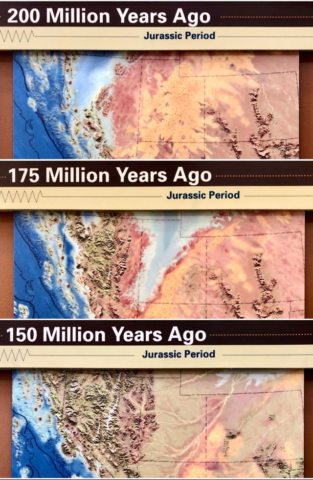
All of this has been determined by geologic investigation of the various sedimentary layers that have been laid down throughout the region over time. The most common layer at the Twenty Mile Wash Dinosaur Track Site is the Entrada Sandstone Formation, dated between the Middle and Late Jurassic Period, say 140 to 175 million years ago.
Having arrived at the Dinosaur Track Site, we climbed up to the upper bench of Entrada Sandstone:
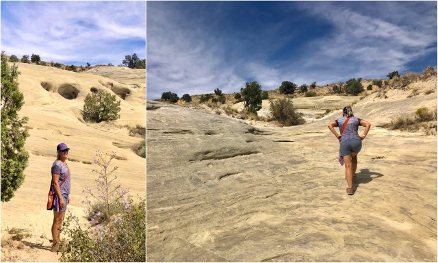
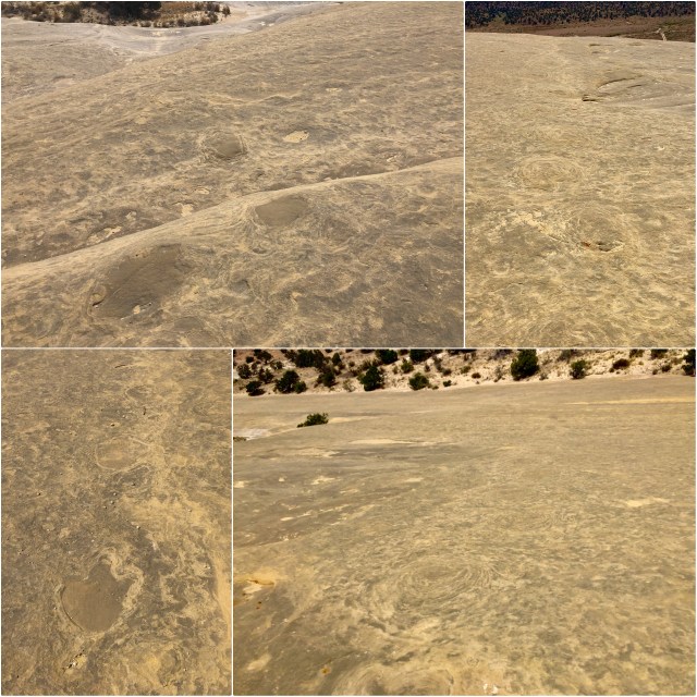
A 2012 scientific journal article written by Robert Eves, Gayle Pollock and Larry Davis that I found since our visit to the Dinosaur Track Site describes the geology and findings made by the paleontologists and geologists who studied it. There are supposedly several hundred dinosaur footprints preserved in the rock here, primarily in the upper bench. We wandered around, looking for evidence of them.

The tracks are not obviously apparent and, at first, we walked right by them. They look like flattened cow-pies; you can see one in the bottom of the photo, above. The tracks appear as darker areas, surrounded by concentric rings of petrified, deformed sand.
Two different types of dinosaur tracks have been identified here: Megalosauripus, a biped with 3-toed, bird-like tracks, suggesting a walking speed of slightly over 3 mph; and Brontopodus, a tail-dragging quadruped. There may also have been a third, smaller dinosaur here: Therangopodus, but tracks for that one have not been clearly identified.
We were only able to find Megalosauripus tracks. As you can see, below, Megalosauripus was rather large, its “feet” measuring between 16 and 30 inches in length; this one was about 24″ long and 14″ wide:
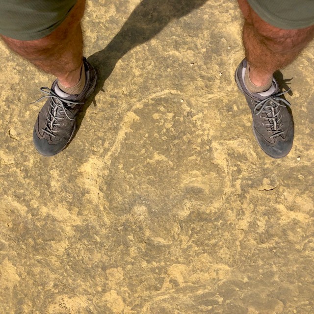
Megalosauripus was similar in appearance to the Velociraptors that were the stars of the Jurassic Park movies, only bigger. Megalosauripus measured as long as 30 feet from nose to tail, and tracks of those dinosaurs from that time period have been found not only in Utah and Arizona, but also in Portugal and Turkmenistan! This was not just a local lizard.

According to the Eves/Pollock/Davis article, describing the scene here at the track site:
As the Sundance Sea withdrew northward, a vast desert [similar to the Sahara] developed. Large-scale, cross-bedded sands of the Entrada Formation were deposited over tidal flat mudstones.
We tried to envision what the world must have looked like here 150,000,000 years ago. That plain before us would likely have been covered over by the retreating Sundance Sea; the mountains in the distance would have been islands; and we would have been standing on the wet sand shoreline, just as the dinosaurs had done eons before.
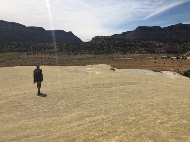
Turning to the north, we could just make out where at least one carnivorous Megalosauripus had wandered along the shoreline (just to the right of the shelf):
Once we knew what to look for, we started seeing Megalosauripus tracks everywhere.
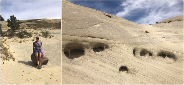
After spending about half an hour examining the dinosaur tracks, we headed back down to the Jeep, stopping to wonder if Dale might have been resting on a remnant of the meteor that struck the earth around 66 mya, causing the extinction of the dinosaurs.
We also wondered at the odd holes in the sandstone. One current hypothesis is that they were caused by air bubbles being trapped in the sand, allowing water to flow through the sand, thus preventing the sand grains from being cemented together into sandstone.
Back in the Jeep, we bounced along south on the Hole-in-the-Rock Road for another 20+ miles to the Dry Forks Slots pull-off, all the while, listening to our cargo of boulders from Smith Mesa sliding and crashing around in back.
There were several cars parked at the trailhead into the Dry Forks Slot Canyons when we arrived at the top of the mesa. We grabbed our sunglasses and water bottles and headed down into the canyon.
It was about a mile hike down slickrock to the river bed where we walked along, following the sandy path toward the junction where we would have to decide which of three slot canyons we would explore: Dry Fork, to the left; Peek-a-Boo Gulch, straight ahead; or, Spooky Gulch, to the right.
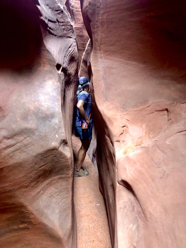
Dry Fork didn’t look that interesting and Peek-a-Boo had a difficult entry with a 10 to 12 foot climb up at the outset (below, top left), so we turned right and continued down the streambed and sand to the entrance to Spooky Gulch (below, bottom right).

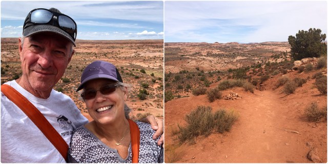
Here’s Dale posing at the entrance to Spook Gulch slot canyon; pretty narrow going in.

And it got narrower and narrower, to the point that it was necessary to turn our heads and suck in our tummies to pass through.
But it was fun working our way back as far as we could. I’m guessing we went in about 300 feet before it got so narrow we could go no further (my GPS couldn’t get a signal once we were inside).
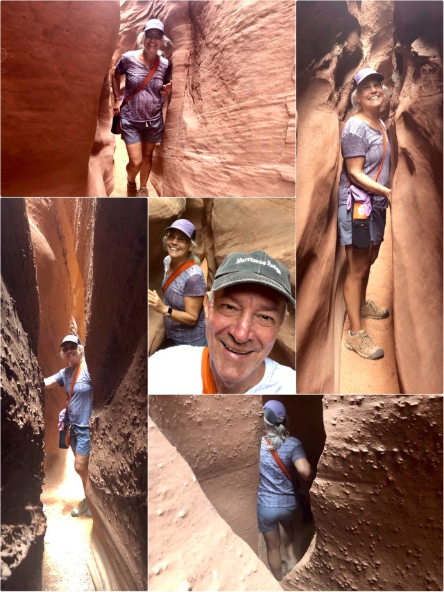
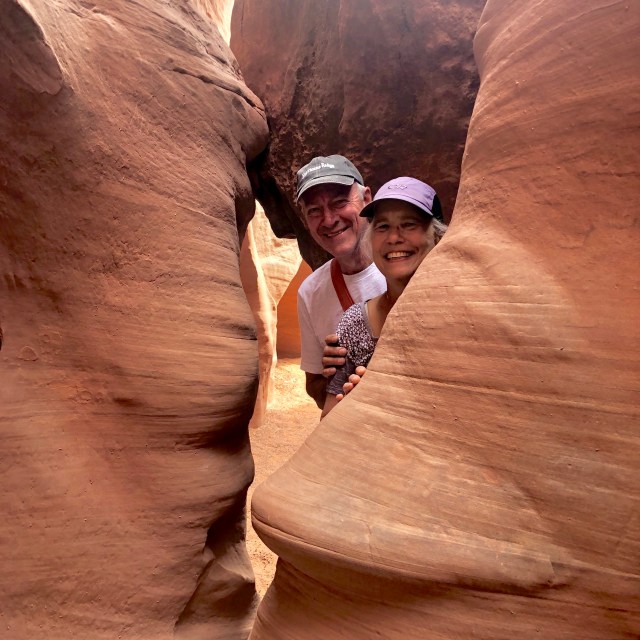
Toward the end, we heard voices echoing from in front of us. Soon, we caught up to another couple, stopping to take mutual portraits.
So, there you have it, a taste of the “exemplary opportunities for geologists, paleontologists, archeologists, historians, and biologists” here in the Grand Staircase-Escalante National Monument. Certainly deserving of preservation in order to be experienced and enjoyed by all.
But that’s not the end of the story.
In 2017, also by executive proclamation, and in furtherance of his campaign promise to increase fossil fuel production in the United States, President Donald Trump modified the boundaries of the Grand Staircase-Escalante National Monument, reducing its size by about 40%, to 1.0 from 1.7 million acres, asserting that Pres. Clinton’s original designation had gone too far, in violation of language in the Antiquities Act restricting National Monuments “to the smallest area compatible with proper care and management of the objects to be protected.”
So, who is right? What is right?
I guess we’ll find out in a couple years, since the matter is now in litigation in the federal court system in a action brought by (among others) the Southern Utah Wilderness Alliance. The Wilderness Alliance is also attempting to have 9.2 million acres of federal land in Utah, including all of the original Grand Staircase-Escalante National Monument lands, designated “Wilderness” by Congressional Act, America’s Red Rock Wilderness Act.
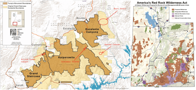
I should note that 2 of the 3 areas we have visited (Willis Creek Canyon and the Dinosaur Tracks Site) that were within the original boundaries of Grand Staircase-Escalante National Monument are unaffected by Pres. Trump’s boundary change, but Spooky Canyon now falls outside of it, as does part of Burr Trail which we will be visiting tomorrow.
I would go a step further than the Wilderness Alliance and ask that the original Grand Staircase-Escalante National Monument be made a National Park.
I was thinking Jurassic National Park might be a good name for it.

Hear hear on protecting the national lands. Don’t get me started on Trump…
LikeLike