Even after being reduced in size by President Trump from 1.7 to 1.0 million acres, Grand Staircase-Escalante NM is still, by far, the largest of all the National Monuments and National Parks in Utah. Consequently, in order to really appreciate it, you need to drive it.
We have already driven into the Monument from the south and west, and yesterday’s excursion down Hole-in-the-Rock Road took us into the Monument’s heart. Today, we drive the northeastern flank of the monument, known colloquially as “Looping the Fold” (the Capitol Reef NP Visitor Center sells a very helpful Loop the Fold Road Guide).
Heading north from Escalante on Scenic Byway UT-12 toward the little town of Boulder (pop. 225), the road climbs past the trailhead to the Lower Calf Creek Falls, then continues over the “Hogback” (more on that later).
Boulder was considered one of the most remote towns in the United States until 1941 when the first road to Boulder was completed. Prior to that, the community’s mail and supplies were delivered by mule from nearby Escalante.
Once in Boulder, we stopped for lunch at Hell’s Backbone Grill & Farm, one of only two places to eat. It turned out to be the best meal of the trip! Nice surprise. After lunch, we stopped at the Anasazi State Park Museum to see the ruins and artifacts excavated here in 1958-59.
The Anasazi were ancestors of the Pueblo Indians. They were village-dwelling farmers that lived on the Colorado Plateau between 1 A.D. and 1300 A.D. The village here at modern-day Boulder, thought to have housed up to 200 people, consisted of 11 pit structures and 97 rooms, many of which were in two L-shaped structures. The village is believed to have been built sometime between 1129-1160 A.D., based on tree-ring dating of surviving structural timbers.
The ruin of one of the L-shaped buildings is depicted in the photo, below, top right; the bottom left is a reproduction. The pit structures were built mostly underground with wood and mud roofs and accessed from the surface by ladder (bottom right). Being underground made the habitations cool in the summer and warm in the winter. By 1235, the Anasazi had left the site, for reasons unknown. The region was not reoccupied until the late 1800s.

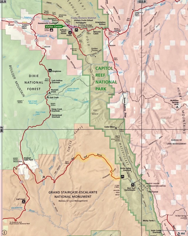
The Loop the Fold drive is a 125-mile circuit. We began the drive on the Burr Trail Road from Boulder at its intersection with UT-12, heading east. The Burr Trail passes through the Grand Staircase-Escalante National Monument (and former Monument lands) for 35 miles, following the route blazed in the late 1800s by John Burr who used it to move livestock between winter grazing range in the desert and summer range in the mountains. At its eastern terminus, the Burr Trail Road intersects with the Notom-Bullfrog Road, which heads north from that intersection to UT-24. The Loop continues west on UT-24 west to UT-12, then south on UT-12, back to Boulder.
The Loop the Fold Road Guide describes the drive this way:
The tour is 125 miles long. Services are available only in and near the towns of Torrey and Boulder. Cell phone service is unreliable for much of the trip. Standard passenger cars may be able to negotiate the loop under typical conditions; however, high-clearance vehicles with sturdy tires are recommended. Nearly 30 miles of the loop are traveled on a graded dirt surface which can be washboarded, sand, and dust in good weather, and impassable during and after storms due to mud, snow and/or ice. Beware of sudden changes in road conditions and abrupt dropoffs due to washouts. Four-wheel drive may be needed depending on current road conditions.
Sounds perfect! The Road Guide goes on to warn that:
Foot and vehicle travel in southern Utah backcountry is light. If you have problems, help may not arrive for hours or even days, depending on the time of year. Be prepared for the unexpected: carry plenty of water, food, gas, adequate clothing, a shovel, and emergency supplies. Cold temperatures can accompany sudden storms or an unexpected night out in the backcountry. Daytime temperatures in the summer may exceed 100 degrees and winter highs may stay below freezing, so dress accordingly.
I guess the shovel is so you can bury those passengers that don’t make it.
Here’s a map of the Loop; I’ve highlighted in yellow that section of the Burr Trail Road that was removed from the Grand Staircase-Escalante National Monument in 2017:
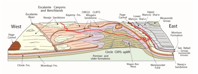
The “Fold” in “Loop the Fold” refers to a geological oddity here that is illustrated, below. Like the rest of the Colorado Plateau, the land here is the result of layers of sediment accumulating over time, in this instance, to a depth of 10,000 feet, laid down over 200 million years in 19 distinct layers of sedimentary rock.
Sometime between 35 and 75 million years ago, plate tectonics resulted in a general uplifting of the Colorado Plateau, but here, due to an existing fault, the uplifting primarily occurred west of the fracture, resulting in what geologists call a “monocline.” The result was a deformation of the sedimentary layers which then molded and “folded” over the subsurface fault. As the surface layers subsequently eroded, the strata of these tilted, folded layers of sediment were exposed.
Today, this geologic feature is known as the Waterpocket Fold and it runs about 100 miles in a north/south direction. Notom-Bullfrog Road runs up the Strike Valley, parallel to Waterpocket Fold (I have drawn our route along the Burr Trail and Notom-Bullfrog Roads in red, below).
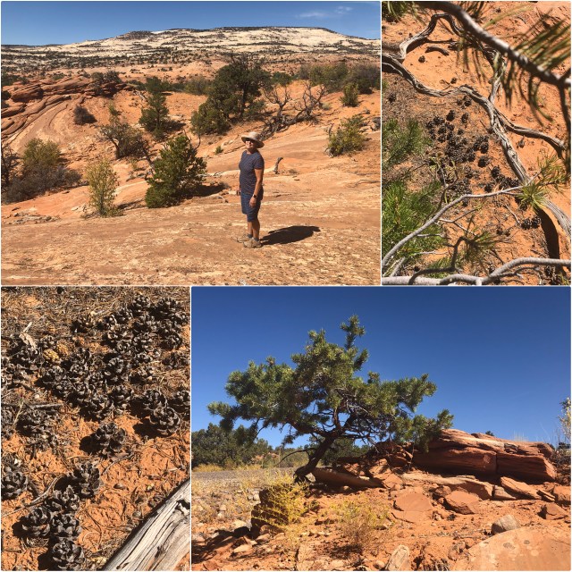
Perhaps 10 miles east of Boulder, we pulled off the road to hike on the sandstone and siltstone of the Kayenta Formation. Those hills in the background in the photo, below (top left) consist of white Navajo Sandstone. Elsewhere, the Navajo Sandstone we’ve seen has been red, a result of oxidation of the iron that is part of its makeup. But, here, water has caused the iron to leach out of the rock, so it is white.
We had also stopped here to look at the Pinyon (or Piñon) Pines that grow at this elevation (around 6,000 feet). Notice how all the pinecones have landed the same way on the ground. Ever hear of pine nuts? In North America, these are the plants and pinecones they come from.
A couple miles further east, we stopped at an overlook, to take in the view of Long Canyon (photo, below, top and middle left) and the Circle Cliffs beyond (middle right).

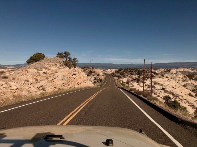
Crossing into Capitol Reef National Park, the road transitioned from pavement to packed dirt; 5 miles further on, we rounded a corner and found ourselves at the beginning of the Burr Trail Switchbacks, right in the middle of the tilted rocks of Waterpocket Fold.

The Switchbacks wind down through Burr Canyon at a 12% grade. If you look closely at the top and bottom panels in the photo, below, you’ll see a pick-up truck with a camper top, slowly winding its way down ahead of us. This, again, is white Navajo Sandstone. In the middle panel, below, you can see Swap Mesa in the distance, and beyond that, the Henry Mountains (elev. 11,522 ft.), the last mountain range in the continental United States to be officially recorded and named.

At the bottom of the Switchbacks, Burr Trail intersects with the Notom-Bullfrog Road which we took north, up Strike Valley through Waterpocket Fold; this is Morrison Formation sandstone, evident from its purple tint.

From its intersection with Burr trail Road, the Notom-Bullfrog Road heads north for 33 miles. The first 17 miles of the road is infrequently-graded dirt, clay and sand; the next 6 miles is gravel; and the northernmost 10 miles are paved.
A few miles north of the intersection with Burr Trail Road, we pulled off the road once again so I could photograph the scene looking back south. To the left (east) is some of the “youngest” rock in Strike Valley, the 300 foot high Mancos Shale cliffs of Swap Mesa, about 90 million years old (photo, below, top). To the right (west) are the rocks of Waterpocket Fold (bottom).

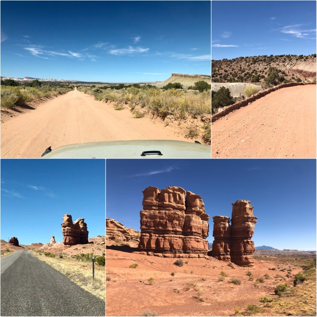
We continued north with Oyster Shell Reef to our east (photo, below, top left – the Reef is on the right). Near the north end of Notom-Bullfrong Road, we pulled off the road for a final time to look at a handful of solitary hoodoos (bottom).
From here, the drive continued through Capitol Reef NP. Since we’ll be visiting the Park soon, we didn’t stop, continuing west on UT-24 to the town of Torrey to see the campground we’ll be staying at; then, back to UT-12 south toward Escalante.
Just south of Boulder (and having completed the Loop), we once again drove over the “Hogback” where UT-12 weaves back and forth along the top of a ridge that’s barely the width of the road pavement with 600-foot drop offs on either side! Yikes! (These photos don’t do it justice.) We continued down the other side back to Escalante and the RV.

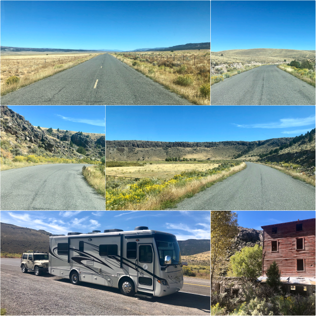
The next morning, we drove to Torrey by back-tracking on UT-12 to Bryce, taking the Johns Valley Road, UT-22, north through Black Canyon to Antimony (photos, below). Having driven across the Hogback twice in the Jeep, I was not excited about doing it a third time in the motorhome, towing. At any rate, the Johns Valley Road route was wonderful, hardly anybody on it. We took it to Otter Creek State Park and the intersection with UT-62 which we took north to UT-24, then east to Torrey.
Next up, Capitol Reef National Park.
