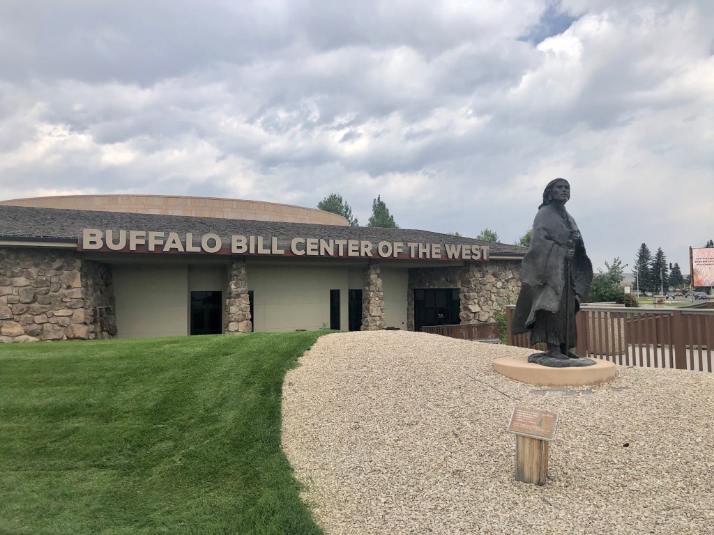
Leaving Yellowstone NP, our goal for the day was to drive to Little Bighorn Battlefield National Monument in Montana. But, having all day to travel the 250 miles, we stopped for a couple hours in Cody, Wyoming, to visit the Buffalo Bill Center of the West.
One of the statutes in front of the Center, shown below, is of Sacajawea, the Shoshone squaw who served as interpreter for Lewis & Clark during that part of their expedition from the Mandan and Hidatsa Indian villages on the Knife River in the Dakotas to the Pacific (Sacajawea also adorns the $1 coin minted in the early 2000s).
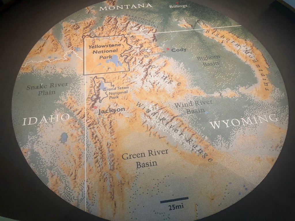
Cody is a two hour drive due east from Bridge Bay Campground on US 20/14, following the Shoshone River most of the way. Inside the Buffalo Bill Center, there’s a huge mural floor map marking Cody’s location in relation to Yellowstone and the three states that meet there:
All of the outdoor and hands-on features of the Center were closed when we arrived due to Coronavirus fears, but that was alright with us, we were there for the museum… or should I say museums – there are five of them under one roof:
- Buffalo Bill Museum – all you want to know about the showman, Buffalo Bill Cody, and his circus-like Wild West Show that toured the USA and Europe from 1883 to 1908;
- Whitney Western Art Museum – featuring paintings by Remington, Bierstadt and contemporary artists;
- Draper Natural History Museum – a kid-friendly animal and dinosaur display (we zipped through this one);
- New Cody Firearms Museum – the most incredible and complete collection of guns I have ever seen – over 4,000 of them; and,
- Plains Indian Museum – incredible exhibits describing and depicting Plains Indian culture and history – this is the one we most wanted to see.
For most of this trip – through modern day Montana, North Dakota, South Dakota and Wyoming – we will be traveling across lands traditionally inhabited by native American Indians, most recently, the seven tribes of the Lakota Sioux.
Prior to President Thomas Jefferson’s purchase of the Louisiana Territory from Napoleonic France in 1803 (from which these four states were later carved), the only Europeans to have appeared in this part of North America were French trappers, like Toussaint Charbonneau, husband of Sacajawea.
So when Capt. Meriwether Lewis and Lt. William Clark were tasked by Jefferson in 1804 to explore the Missouri River, find the mythical Northwest Passage between the Atlantic and Pacific Oceans, make diplomatic contact with the native inhabitants and expand the American fur trade, they had little idea what might lie ahead.
But they knew one thing for sure: there would be Indians.

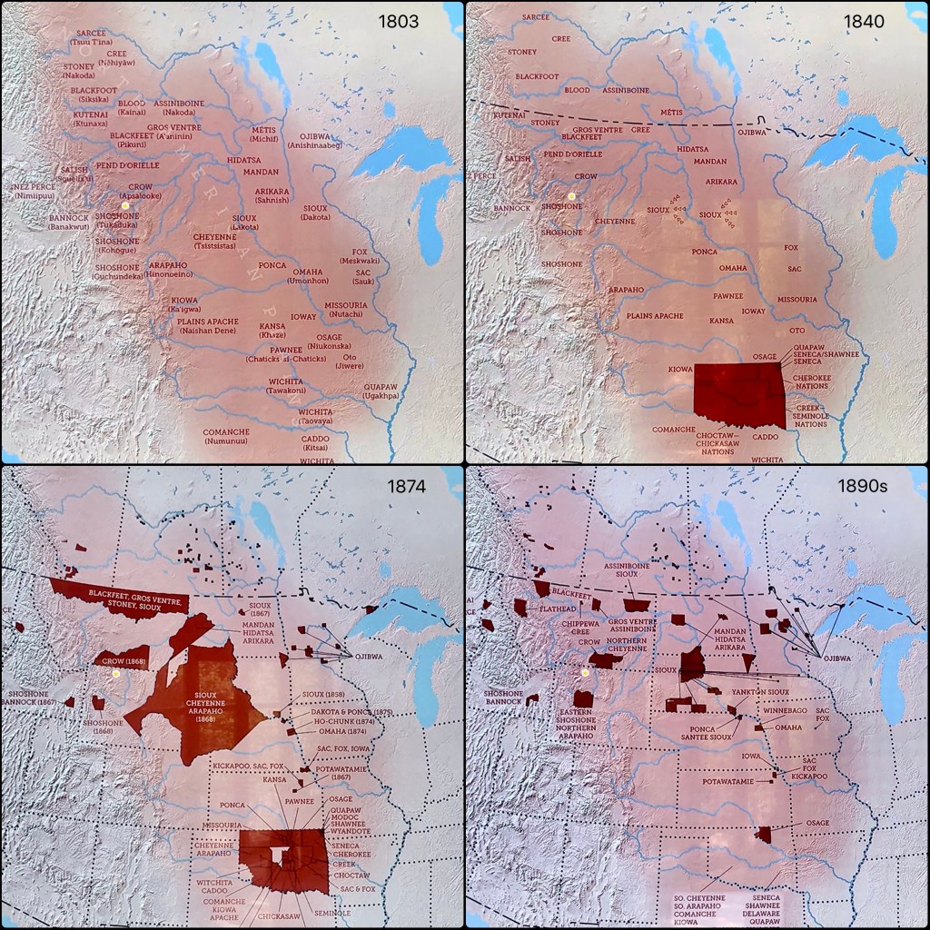
There were several good exhibits in the Plains Indian Museum describing the culture of the various Indian tribes that inhabited these lands and explaining their movements within it up to and during the 19th Century, the 100 years that cost the Indians their land and way of life. I have put them together in the collage, below (Cody is shown as a yellow dot in each of the four quadrants).
The Sioux tribes originally inhabited lands around and below the Great Lakes, but by the early 1700s, they had been pushed westward by other Indians, primarily the Ojibwa in the north and Iroquois further south. In turn, the Sioux displaced the Crow and other tribes that had occupied those western lands into which the Sioux advanced.
By 1800, having acquired the horse and the gun, the Sioux divided into two nations: the Dakota, who remained woodland Indians east of the Missouri River; and, the Lakota, who continued westward to follow and hunt the bison on the steppes of the Missouri Plateau, part of the region we call today the Great Plains (see map marked 1803, below). These steppe lands are barren of nearly all vegetation, with the exception of grasses suitable for grazing, perfect for the tremendous herds of bison that roamed the Plains in the millions in those days. (The “bison,” by the way, evolved away from the “buffalo” over 3 million years ago, although Americans refer to the bison as a “buffalo” nonetheless, for example, “Buffalo Bill.”)
But all of the Plains Indians – not just the Sioux – relied on the bison, not only for food, but also for clothing and shelter (teepees) made from the hides, so there was fierce competition among the tribes to gain and protect access to these important hunting grounds. By 1840, the Lakota Sioux had driven all competitors out of the region (see map marked 1840, below).
And then the White Man arrived in number, chasing gold, land and Manifest Destiny, and having already forced the southeastern Indians onto reservations in what today is Oklahoma (my maternal grandmother grew up on the Quapaw reservation).
From the early 1840s through the 1860s, pioneers ventured westward on the Oregon Trail to the Pacific Northwest, often accompanied by U.S. military troops. This, of course, was not welcomed by the Sioux or other native Indians who raided and skirmished with the intruders. (Hinting at how it expected future relations with the Indians to evolve, in 1824, Congress established the Bureau of Indian Affairs within the Department of War, today’s Department of Defense.)
In 1851, the United States federal government and the upper Great Plains tribes attempted to end these Indian/American (as well as inter-tribal) conflicts and establish a lasting peace by entering into the Fort Laramie Treaty in which exclusive Indian tribal lands were delineated, the Sioux (together with their Cheyenne and Arapahoe allies) retaining most of the region. The treaty also provided that in exchange for annuity payments from the federal government, pioneers would be granted safe passage across, and American forts could be built along, the Oregon Trail.
But, thanks to three things that took place in 1862, shortly after the outbreak of the Civil War – the discovery of gold in western Montana, the enactment of the Homestead Act (granting free land to settlers) and passage of the Pacific Railway Act (granting land to aid construction of transcontinental railroads) – the peace did not last long. Prospectors, homesteaders and surveyors poured into the region, some along the newly established Bozeman Trail, paying little heed to the Treaty. Ultimately, the ensuing, renewed conflict led to “Red Cloud’s War” and, with the Americans being distracted by the Civil War and then Reconstruction, a second Fort Laramie Treaty was entered into in 1968, closing the Bozeman Trail, removing the military forts and garrisons, and further restricting the reservations to which the Indian tribes were to have exclusive right (see map marked 1874, above).
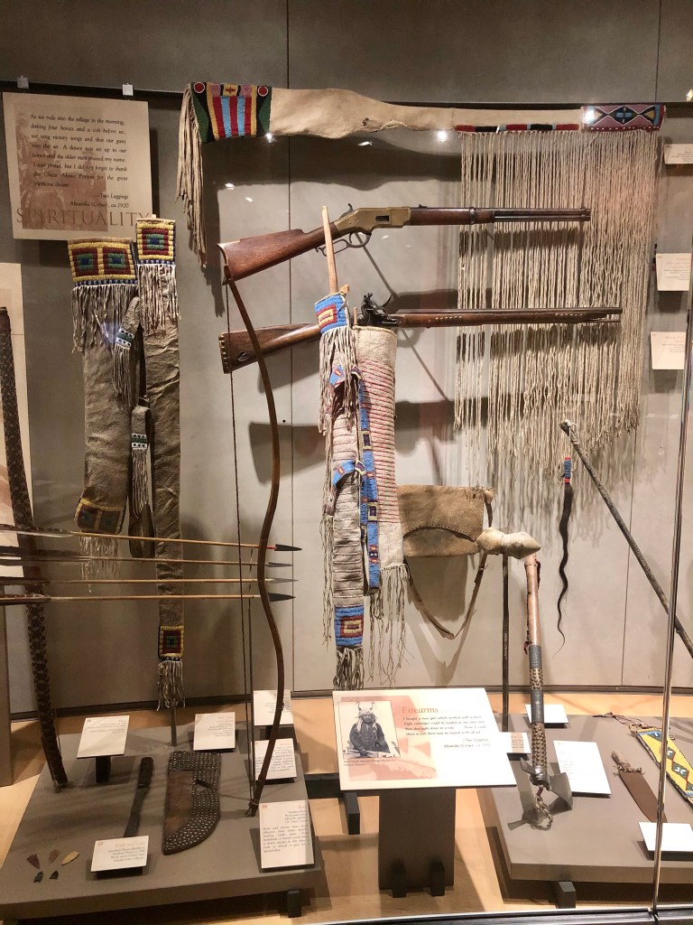
During these years, the U.S. Army had military superiority over the Sioux and other Plains Indians. Most Indian warriors still fought with bow and arrow, tomahawk, war club and lance, with the occasional old flintlock rifle among them, whereas the Army soldiers had much faster loading and firing guns: the breech-loader and, later, lever-action rifles, all shown in the photos, below.
And then came the railroad and the slaughter of the bison herds. Deprived of the bison, the Lakota Sioux, who dominated these Indian lands, became desperate. At the same time, U.S. policy changed from accommodation to transformation – the Indians were to be settled onto smaller reservations and made to become farmers.
Pushed into this corner, the Sioux fought back, leading to the Great Sioux War of 1876/77, pitting Civil War veterans like Generals Sherman and Sheridan – and the infamous Lt. Col. George Armstrong Custer – against respected and experienced Sioux Chiefs Sitting Bull and Crazy Horse in a series of battles that culminated in Custer’s Last Stand at the Battle of the Little Bighorn.
But starving and exhausted, the Sioux were ultimately chased to Canada or run to ground in the river valleys where they surrendered, relinquishing their beloved Black Hills and most of their hunting grounds to the Americans. They were thus restricted to ever-shrinking reservations (see map marked 1890s, above).
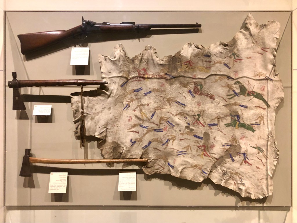
We will be visiting the sites of the most famous battles of both Red Cloud’s War and the Great Sioux War and I will have more to say about them when we do. But, here at the Buffalo Bill Center, I was surprised to discover Sitting Bull’s tomahawk and a waníyetu iyáwapi, that is, a “winter count” bison hide depicting the Battle of the Little Bighorn (bottom and right in photo, below):
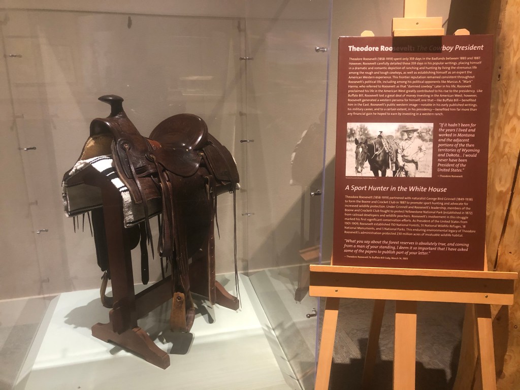
As we were leaving the Center, we passed a beautiful saddle on display near the lobby. It was Teddy Roosevelt’s from his days on the western frontier. We’ll be visiting the ranch and name-sake National Park of the “Cowboy President” (Theodore Roosevelt, 1858-1919; President 1901-1909) when we get to North Dakota in a few days.
I know that was a lot to take in, but I wanted to set the stage for what’s to come. For those that like history, you’re welcome; for those that don’t, Sioux me.

Great story. You could become a professor of history in your next life.
LikeLike
It’s my secret passion 🙂
LikeLike
We are back home and catching up. I was surprised to read that the outdoor stuff was closed yet the museum was open. In our travels, (only Oregon and Southern WA), all museums and visitor centers were closed. All you could do was walk the trails and read the outdoor stuff that existed there.
However, we did love how empty things were. In Mt. Rainier, we could stop the car in the middle of the road and look at the waterfalls. Of course, it was pouring and 45 degrees…
Hope to see you. I think I remember that you won’t be in Gainesville until December. Bill will probably have a doctor appointment then. He has one next week. Our daughter is back in Gainesville for her last year. She got Covid (in Gainesville), but wasn’t very sick, and quaranteened herself here while we were gone so she had plenty of space and the animals to keep her company. Our friends and our son were good about bringing her food. I couldn’t believe she was so good about staying home since she felt fine. We told her that she can go out in Gainesville now since she is safe for at least another few months.
Emily ________________________________
LikeLike
Em, yes, Florida in December. Our experience in the Great Plains was the same as yours in Oregon: visitor centers mostly closed. Buffalo Bill Center is privately owned, and remote, so they had the museums open, but not enough clientele to justify the outdoor stuff. See you when we’re back!
LikeLike
Pingback: Back to the Future | The Road Less Traveled
Pingback: Little Missouri | The Road Less Traveled
Pingback: Little Missouri | The Road Less Traveled
Pingback: Facial Recognition | The Road Less Traveled